Welcome to the consultation for the St John’s Road Travel Improvements project.
What’s on this page
- Project overview
- What are we proposing?
- Consultation event
- Have your say – take the survey
Project overview
Hertfordshire County Council is working in partnership with Watford Borough Council to improve walking, wheeling and cycling routes across Watford. The proposed improvements are supported by Active Travel England and form part of the wider Watford Green Loop, a 6.5-mile route that encircles Watford town centre. The route connects from Watford Junction, a busy transport hub, to green open spaces such as Cassiobury Park and heritage sites using parts of the National Cycle Network Route 6 and Ebury Way.
As part of the Watford Green Loop programme, improvements at Thomas Sawyer Way were completed and opened in April 2026. Proposals for Lower High Street were consulted on in September 2026, with feedback currently under review. St John's Road is the next project to be progressed and is now at the consultation stage.
The proposed improvements aim to make it safer and easier for people of all ages and abilities to walk, wheel and cycle, while improving connections between local communities, key destinations and the wider Watford Green Loop route.
The project aims to:
- Improve accessibility along St John's Road, making it easier to travel between Albert Road through to Queen's Road Junction, and surrounding local destinations.
- Provide a new westbound contraflow cycle route connecting Watford town centre and Watford Junction station. A contraflow cycle lane will provide a more direct westbound route along St John's Road, improving access between the town centre and station.
- Improve safety and accessibility for pedestrians through upgraded crossings, including improvements at the Queen's Road Junction.
- Provide safer and more convenient walking, wheeling and cycling facilities through new segregated and shared-use routes, wider footways and improved surfaces.
- Enhance the Watford Green Loop by creating a safer, more accessible and better connected route for people of all ages and abilities.
- Improve the appearance and usability of St John's Road through new planting, seating areas, improve signage, and other public realm improvements.
What are we proposing?
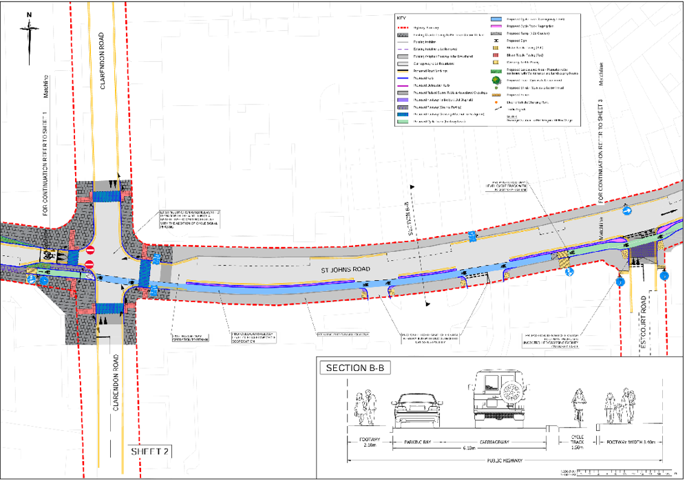
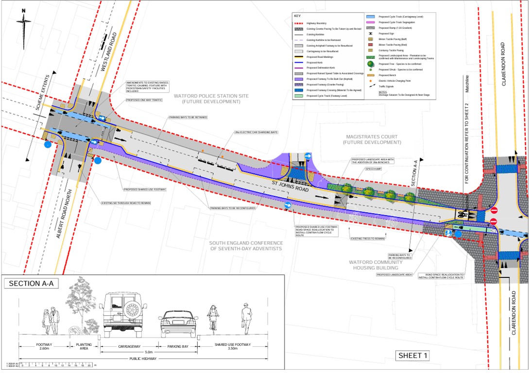
1. A new shared-use walking, wheeling and cycling route crossing between Clarendon Road and Albert Road North, created through widening and resurfacing the existing footway to make journeys safer and more accessible.
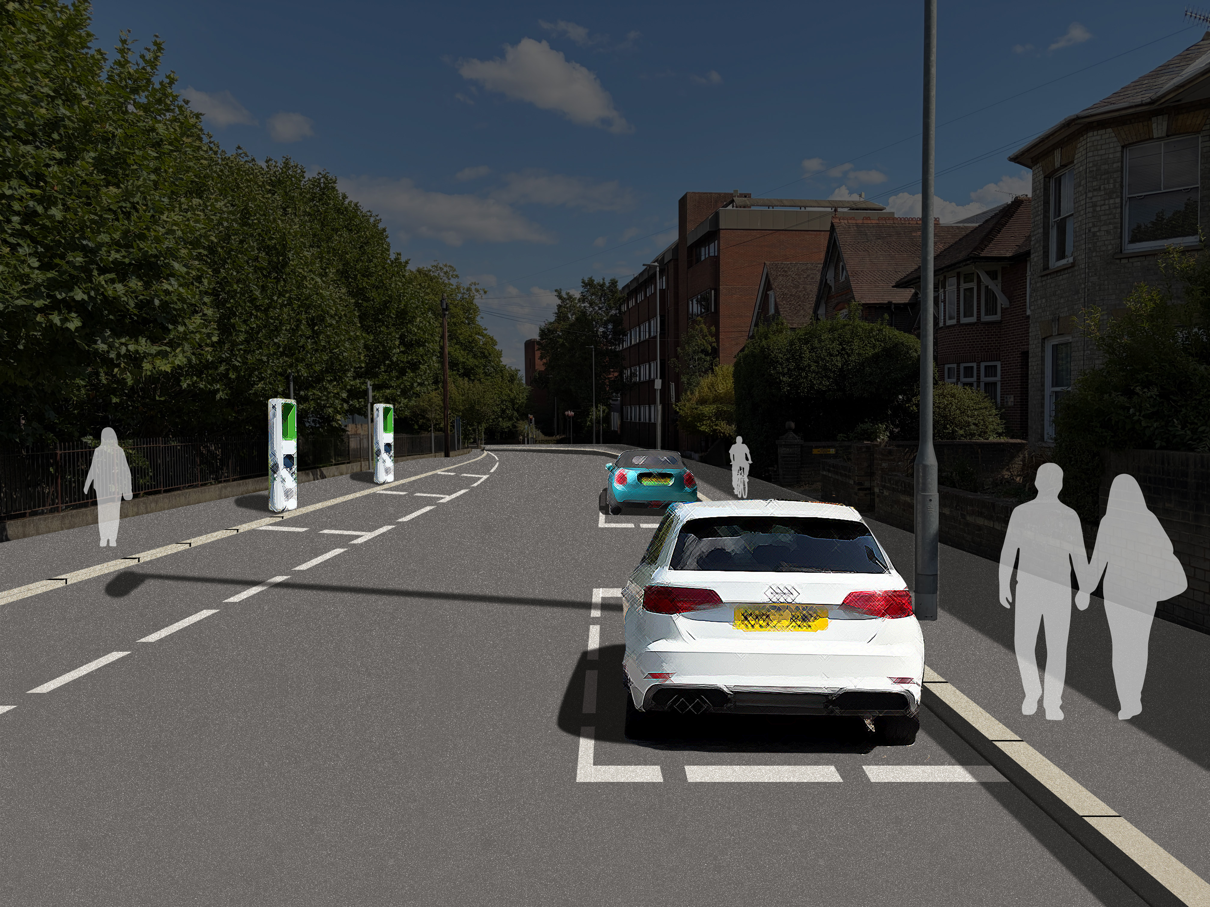
The improvements form part of a longer-term plan to improve the junction by providing signal-controlled pedestrian crossing facilities on all arms. The junction currently has uncontrolled pedestrian crossings, and these changes will make it safer and easier for people to cross in all directions.
The proposed shared-use route will be a minimum of 3.2 metres wide, providing ample space for people walking, wheeling and cycling. Cyclists will be only be travelling west bound through this section, and clear signage will be provided to help everyone use the route safely and confidently.
Changes to the existing on-street parking arrangements will be required to accommodate the new layout and improve conditions for people walking and cycling. A small number of existing parking spaces will be affected. These changes have been carefully considered and are necessary to support the delivery of a safer and more accessible environment for all road users. To find out more view the consultation drawings below.
2. A new westbound contraflow cycle lane along St John's Road, between the Queen Street and Clarendon Road junctions.
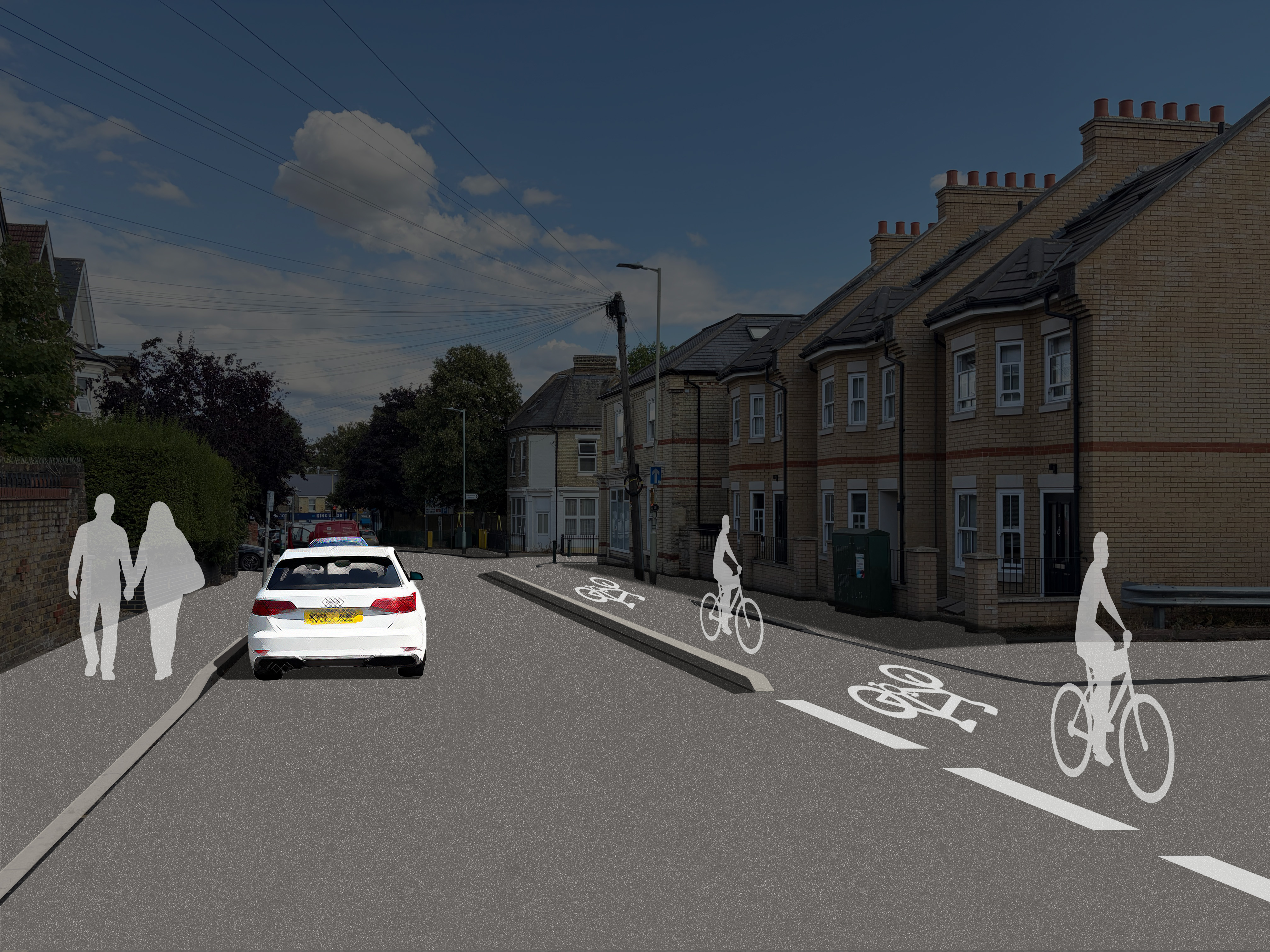
A contraflow cycle lane will allow people cycling to travel in the opposite direction on this one-way street. This will improve cycle connectivity by providing a more direct westbound route and making journeys easier and more convenient.
The improvements include a new island along St John's Road. The islands are raised sections of road that create separation between different road users.
This will help to improve safety and provide a more comfortable environment for people cycling.
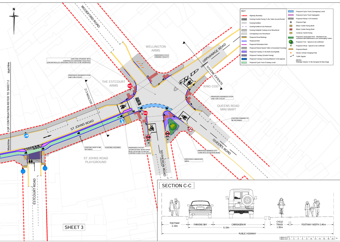
3. Junction upgrades to improve cyclist facilities along St John's Road
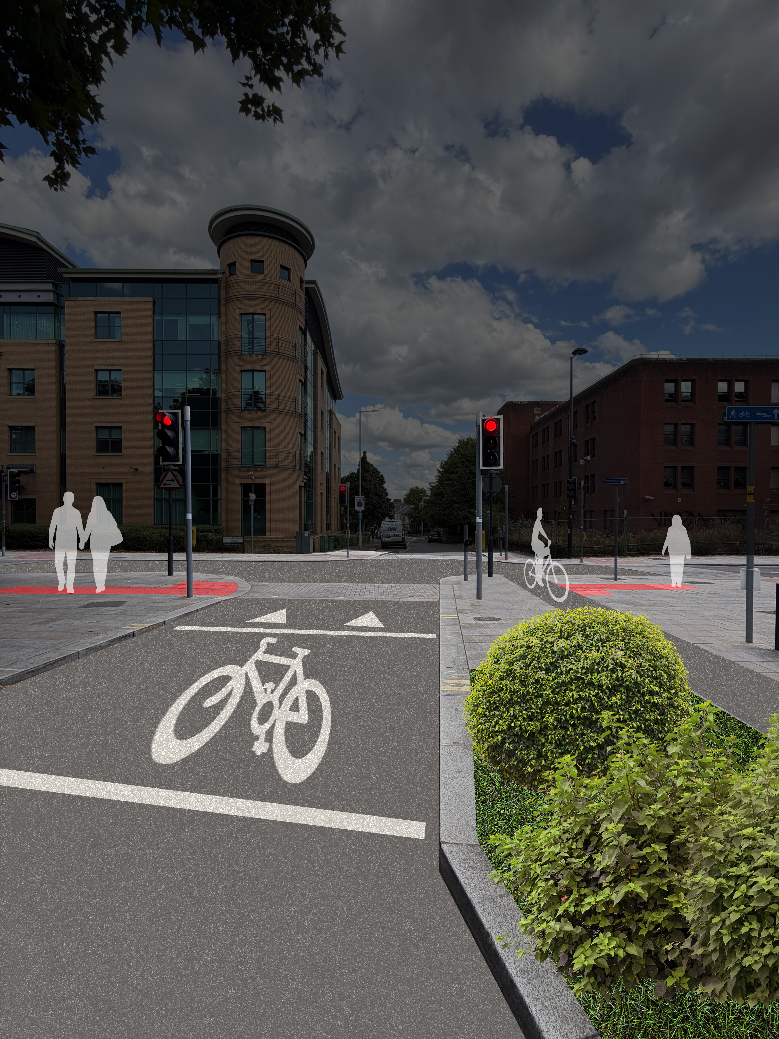
The upgrades will provide a westbound connection along St John’s Road for cyclists and enhance access to the town centre and Watford Junction station.
A contraflow cycle lane will allow people cycling to travel in the opposite direction on this one-way street. This will improve cycle connectivity by providing a more direct westbound route and making journeys easier and more convenient.
The improvements also include new cycle signage to help guide cyclists and support safer journeys through the area.
4. Improvements to cyclist and pedestrian facilities on Orphanage Road
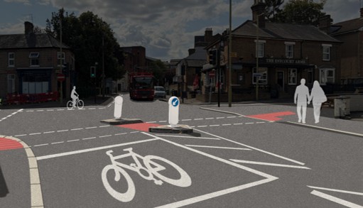
The improvements include a new advanced stop line for cyclists, allowing people cycling to wait ahead of traffic at junctions. This improves visibility, making it safer for cyclists and supporting smoother traffic flow.
The proposals also include new planting along St John's Road to help create a more attractive street environment.
Together, these improvements will encourage more people to walk, wheel and cycle as an alternative to travelling by car.
Project drawings
The full design of the proposed scheme can be seen in the consultation drawings below.
Consultation event
We are holding an exhibition of our proposals on Saturday 28 November 2026 from 10am to 2:30pm at Watford Library, Hempstead Road, Watford, Herts WD17 3EU.
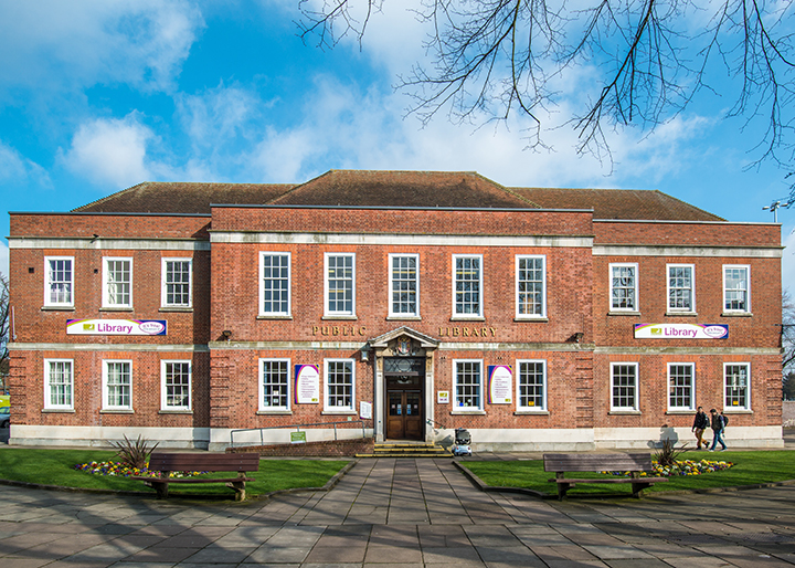 Watford Library, Hempstead Road, Watford, Herts WD17 3EU
This is a 'drop-in' event, and you are welcome to attend at any point during its hours.
You are invited to view our proposals in more detail and discuss them with the project team, who will be available to answer any questions you may have.
Have your say
Our public consultation on these proposals opens on Monday, 16 November 2026, and will run for 5 weeks, before it closes at 11:59pm on Monday, 21 December 2026.
The best way to have your say is by completing the online survey at the bottom of this page.
Printed copies of the consultation information and survey will be available to collect from Watford Library, Hempstead Road, Watford, WD17 3EU from Saturday 28 November 2026. Alternatively, printed copies of the project information, and survey, can be requested by emailing ATFConsultation@hertfordshire.gov.uk.
Contact us
Welcome to the consultation for the St John’s Road Travel Improvements project.
What’s on this page
- Project overview
- What are we proposing?
- Consultation event
- Have your say – take the survey
Project overview
Hertfordshire County Council is working in partnership with Watford Borough Council to improve walking, wheeling and cycling routes across Watford. The proposed improvements are supported by Active Travel England and form part of the wider Watford Green Loop, a 6.5-mile route that encircles Watford town centre. The route connects from Watford Junction, a busy transport hub, to green open spaces such as Cassiobury Park and heritage sites using parts of the National Cycle Network Route 6 and Ebury Way.
As part of the Watford Green Loop programme, improvements at Thomas Sawyer Way were completed and opened in April 2026. Proposals for Lower High Street were consulted on in September 2026, with feedback currently under review. St John's Road is the next project to be progressed and is now at the consultation stage.
The proposed improvements aim to make it safer and easier for people of all ages and abilities to walk, wheel and cycle, while improving connections between local communities, key destinations and the wider Watford Green Loop route.
The project aims to:
- Improve accessibility along St John's Road, making it easier to travel between Albert Road through to Queen's Road Junction, and surrounding local destinations.
- Provide a new westbound contraflow cycle route connecting Watford town centre and Watford Junction station. A contraflow cycle lane will provide a more direct westbound route along St John's Road, improving access between the town centre and station.
- Improve safety and accessibility for pedestrians through upgraded crossings, including improvements at the Queen's Road Junction.
- Provide safer and more convenient walking, wheeling and cycling facilities through new segregated and shared-use routes, wider footways and improved surfaces.
- Enhance the Watford Green Loop by creating a safer, more accessible and better connected route for people of all ages and abilities.
- Improve the appearance and usability of St John's Road through new planting, seating areas, improve signage, and other public realm improvements.
What are we proposing?
1. A new shared-use walking, wheeling and cycling route crossing between Clarendon Road and Albert Road North, created through widening and resurfacing the existing footway to make journeys safer and more accessible.
The improvements form part of a longer-term plan to improve the junction by providing signal-controlled pedestrian crossing facilities on all arms. The junction currently has uncontrolled pedestrian crossings, and these changes will make it safer and easier for people to cross in all directions.
The proposed shared-use route will be a minimum of 3.2 metres wide, providing ample space for people walking, wheeling and cycling. Cyclists will be only be travelling west bound through this section, and clear signage will be provided to help everyone use the route safely and confidently.
Changes to the existing on-street parking arrangements will be required to accommodate the new layout and improve conditions for people walking and cycling. A small number of existing parking spaces will be affected. These changes have been carefully considered and are necessary to support the delivery of a safer and more accessible environment for all road users. To find out more view the consultation drawings below.
2. A new westbound contraflow cycle lane along St John's Road, between the Queen Street and Clarendon Road junctions.
A contraflow cycle lane will allow people cycling to travel in the opposite direction on this one-way street. This will improve cycle connectivity by providing a more direct westbound route and making journeys easier and more convenient.
The improvements include a new island along St John's Road. The islands are raised sections of road that create separation between different road users.
This will help to improve safety and provide a more comfortable environment for people cycling.
3. Junction upgrades to improve cyclist facilities along St John's Road
The upgrades will provide a westbound connection along St John’s Road for cyclists and enhance access to the town centre and Watford Junction station.
A contraflow cycle lane will allow people cycling to travel in the opposite direction on this one-way street. This will improve cycle connectivity by providing a more direct westbound route and making journeys easier and more convenient.
The improvements also include new cycle signage to help guide cyclists and support safer journeys through the area.
4. Improvements to cyclist and pedestrian facilities on Orphanage Road
The improvements include a new advanced stop line for cyclists, allowing people cycling to wait ahead of traffic at junctions. This improves visibility, making it safer for cyclists and supporting smoother traffic flow.
The proposals also include new planting along St John's Road to help create a more attractive street environment.
Together, these improvements will encourage more people to walk, wheel and cycle as an alternative to travelling by car.
Project drawings
The full design of the proposed scheme can be seen in the consultation drawings below.
Consultation event
We are holding an exhibition of our proposals on Saturday 28 November 2026 from 10am to 2:30pm at Watford Library, Hempstead Road, Watford, Herts WD17 3EU.
Watford Library, Hempstead Road, Watford, Herts WD17 3EU
This is a 'drop-in' event, and you are welcome to attend at any point during its hours.
You are invited to view our proposals in more detail and discuss them with the project team, who will be available to answer any questions you may have.
Have your say
Our public consultation on these proposals opens on Monday, 16 November 2026, and will run for 5 weeks, before it closes at 11:59pm on Monday, 21 December 2026.
The best way to have your say is by completing the online survey at the bottom of this page.
Printed copies of the consultation information and survey will be available to collect from Watford Library, Hempstead Road, Watford, WD17 3EU from Saturday 28 November 2026. Alternatively, printed copies of the project information, and survey, can be requested by emailing ATFConsultation@hertfordshire.gov.uk.
Contact us